ADVERTISEMENTS:
Do you want to create an amazing science fair project on soil erosion. You are in the right place. After reading this article you will learn about:- 1. Introduction to Soil Erosion 2. Factors Affecting Soil Erosion 3. Effects 4. Soil Erosion Caused by Water 5. Soil Erosion Caused by Wind.
Contents:
- Science Fair Project on the Introduction to Soil Erosion
- Science Fair Project on the Factors Affecting Soil Erosion
- Science Fair Project on the Effects of Soil Erosion
- Science Fair Project on the Soil Erosion Caused by Water
- Science Fair Project on the Soil Erosion Caused by Wind
Science Fair Project # 1. Introduction to Soil Erosion:
Commonly speaking, soil erosion generally refers to detachment and transport of soil and soil material by water, wind, ice or gravity — water and wind being the major factors. Large flood plains and coastal plains are formed due to wearing of mountains.
ADVERTISEMENTS:
However, this steady and slow process of nature is nondestructive, and is, therefore, known as ‘natural erosion’ or ‘geological erosion’. Geological erosion is not detrimental to man’s well-being and is wholly beyond his control.
Contrary to this, when nature’s balance is disturbed by human activities like large scale cutting of forests, leveling and cultivation, etc., the process of erosion is speeded up manifolds. The surface one-inch soil which may be formed in thousand years can be lost in just one year.
This rapid erosion, as a result of human interference, is known as accelerated erosion. In common parlance, unless specifically mentioned, erosion refers to accelerated erosion.
Thus, erosion consists of:
ADVERTISEMENTS:
(i) Detachment of soil particles from the surface; and
(ii) Their transportation that requires a source to carry the detached particles away.
No substantial erosion is possible unless both the processes are operative. Soil particles must be dislodged first from their mass before they can be splashed, rolled, slid or carried in suspension along the surface. In soil erosion by water, these processes are largely the result of raindrop splash, turbulence of moving water caused by raindrops and flowing water.
When raindrops strike the soil surface they breakdown the clods and smaller aggregates. The detached soil materials are then transported along with the flowing water and finally deposited in depressions or plains when the flow velocity is reduced. The falling raindrops and surface flow (runoff) produce widely different effects on soil.
Science Fair Project # 2. Factors Affecting Soil Erosion:
The major variables affecting soil erosion, viz., climate, soil properties, topography, vegetation and other related factors, are briefly described below.
(i) Climate:
ADVERTISEMENTS:
Climatic variables affecting erosion are precipitation, wind velocity, temperature, and humidity and radiation receipts. Precipitation is the most forceful factor causing erosion through splash and surface runoff (Table 1.1).
Water drops falling on the soil surface exert considerable force depending upon the size of the drop — the bigger the drop, the greater is the impact with which it strikes the land and consequently detaches and splashes the soil particles.
ADVERTISEMENTS:
These separated and displaced particles are then carried along with the runoff water. Runoff may occur without erosion but there is never erosion without runoff. Runoff that causes erosion is dependent on amount, duration, intensity and frequency of the rainfall and also the time of the season when rainfall occurs. High intensity downpours invariably cause maximum runoff.
Observations indicate that all rains in excess of 5 cm/day always cause runoff, whereas those below 1.25 cm/day cause runoff occasionally. The effect of climate on natural vegetation and on soil development shows that soil and vegetation boundaries coincide in a general way with climatic boundaries.
Consequently, climate affects the erosion conditions of an area directly as well as through the vegetation that occurs. In arid climates, wind erosion is more severe than in humid ones. Lack of organic matter in soils of arid and semi-arid regions makes them more susceptible to erosion by water as well as by wind.
In terms of temperature, the climate is defined as tropical, sub-tropical, temperate, cold temperate, arctic and sub-arctic. Generally, rainfall intensity increases near the equator because of the ability of warm air to absorb more water.
ADVERTISEMENTS:
Therefore, erosion by water is quite serious in tropical and sub-tropical countries. The amount of annual precipitation is affected by the prevailing wind, the distance from the sea, the topography and the temperature.
The cooler the climate, the more likely it is for rainfall to be gentle. In arctic regions, water erosion would be of little consequence even if there were extensive agriculture, because there is little rainfall.
Similarly, strong winds mainly in arid and semi-arid areas cause considerable soil loss through saltation, suspension and surface creep. Soil particles are picked up from one location and are blown to another, often hundreds of kilometres away. Wind erosion causes dust storms, forms sand dunes, buries localities with deposition and creates drier conditions.
(ii) Soil Properties:
Soil erodibility is largely dependent upon texture, structure, organic matter, nature of clay and the amounts and kinds of salts present. Generally, fine textured and alkali soils are more erodible. On the other hand, soils with low silica/sesquioxide ratio, common in humid tropics, e.g., latosals and other lateritic soils, are reported to be less erodible.
Soils with greater absorptive and retentive capacities reduce runoff and are, therefore, less erodible. Also, soils that have dried out thoroughly become highly erodible when exposed to rain storm. This is particularly true if little or no vegetation remains at the end of the dry period. Soils of high detachability and high transportability are highly erodible.
Coarser textured soils containing a greater proportion of sand are more susceptible to wind erosion. This applies to all sand fractions less than about 1 mm in diameter. In addition, low silt, clay and organic matter content in such soils deters clod formation, and even if some clods are formed they are far less stable. In general, any process which reduces consolidation usually increases erodibility.
(iii) Topography:
Slope accelerates erosion as it increases the velocity of the flowing water. Observations indicate that a four-time increase in the degree of slope doubles the velocity of flowing water which can increase its erosive power four times and the silt-carrying capacity 32 times.
Unidirectional general slope of the field results into sheet erosion while an undulating field with local slopes in more than one direction results into rill or gully erosion in addition to imperceptible sheet erosion.
Lateritic soils, associated with rolling topography in high rainfall areas, also suffer from sheet and rill erosion. In the absence of suitable soil conservation measures, these soils may lose about 40 tonnes/ha of valuable top soil in a year. Different characteristics of slope such as steepness of slope, length of slope, configuration, variation in steepness, micro-topography and aspect of slope, all affect the soil erosion.
On nearly level land there is little runoff, because much water is held as depression storage. As the slope increases, the depression storage decreases and the amount and rate of runoff increases. Data given in Tables 1.3 and 1.4 present the magnitude of soil loss under two slope conditions and cropping management systems.
Increasing steepness of slope increases the velocity of runoff and makes the water a better transporting agent. Steepness also allows the raindrop to hit the ground more directly, because the sheet of water on the surface becomes thinner as the flow velocity increases.
The effective length of slope in erosion studies is measured from the beginning of overland flow to the point where the water flows into a well-defined channel or where the slope diminishes so much that deposition occurs.
Configuration of the slope, i.e., convex or concave also affects soil erosion. For example, sheet erosion is more severe on a convex slope than on a concave one due to drying rate, soil depth, steepness, resulting into high flow velocity.
Non-uniformity of slopes from crest to valley also affects runoff and erosion. On large areas, the erosion losses from variable steepness are less, (due to simultaneous alternation of high and low infiltration rates) than those of the same average slope that are uniform.
Aspect of the slope is also important in causing runoff and erosion. Experience shows that slopes that face south and west in the northern hemisphere suffer more from erosion than those that face north or east.
South slopes are exposed to much greater variations of temperature and moisture than slopes facing in other directions. Southern slopes face the sun more directly and therefore soil dries much more than on the level surface.
Consequently, soil of southern slopes are lower in organic matter content, and because of excessive drying they are much easily detached than relatively more moist soils of the northern hemisphere. North-facing soils are better covered with vegetation than the south-facing ones.
The micro-topography or unevenness of the soil surface may form many small depressions, yielding storage capacity for water and thus giving it more time to infiltrate. Contouring and terracing are examples of man’s attempt to make use of the beneficial properties of micro-topography.
(iv) Vegetation:
The soil erosion becomes severe when the nature’s balance is disturbed by human activities of growing crops and meeting other necessities. The presence of vegetation acts as an erosion-retarding factor. Forests and grasses provide better cover than the cultivated crops.
In general, vegetation intercepts the beating action of falling raindrops, retards the amount and velocity of surface runoff, permits more water flow into the soil, and checks the abrasive power of wind.
It also reduces runoff as part of the intercepted rainfall is evaporated directly from the plant surface. Lack of vegetation creates erosion-permitting conditions. Plant roots and other residues of vegetation help to improve soil aggregation and porosity and thereby enhance infiltration and reduce runoff.
Interception is the interruption of downward travel of rain or snow by vegetative or other soil cover. In the case of very dense vegetation, all rain water is intercepted before it can hit the ground, therefore, the energy with which it drops down is greatly diminished. The interception percentage varies with the density, the type and the height of the vegetation.
In a rain storm of long duration the amount of intercepted water that evaporates back into the atmosphere without striking the ground can be considerable. Some of the intercepted water glances off the vegetation and strikes the ground, some of it flows down the trunks of trees or stems of plants as stem flow, and a portion remains in the vegetation after the rain stops and evaporates eventually.
This latter amount of water is called residual interception storage and may be up to the extent of 5 mm for rainwater.
(v) Residue Mulch:
Residue mulch prevents direct impact of raindrop on soil aggregates, maintains pore space continuity and high infiltration rate and enhances crop growth to provide an early ground cover through improvement in soil temperature and moisture.
The effect of different mulch rates on runoff and soil loss from a newly cleaned land and with 10% slope is shown in Table 1.4A. Runoff and soil loss decreases exponentially with an increase in mulch rate.
(vi) Shifting Cultivation:
Shifting cultivation is an important cause of soil erosion in hilly areas of Assam, Orissa, Tripura, Andhra Pradesh, Tamil Nadu, Maharashtra, Kerala, Manipur, Madhya Pradesh and some other states (about 3.65 mha). This is practiced by tribals who indiscriminately cut the forest and set fire after drying the branches and tree trunks.
The Char areas are cultivated for 2 to 3 years and abandoned thereafter for about 5-40 years to allow regeneration of natural vegetation and replenishment of soil fertility. Even the steepest slopes are not spared if otherwise found suitable for cultivation. It has been observed that at-least 10 cm of soil is washed away even from moderate slope in each cycle.
The people who practice shifting cultivation could be:
(i) Primarily dependent on it (living in north-eastern region of India under high rainfall — 2500 mm/year);
(ii) Partially dependent (living in Orissa, Andhra Pradesh — in rainfall zones of 1500-2000 mm/year); and
(iii) Marginally dependent (living in Bihar, Madhya Pradesh, Sikkim, Kerala, Karnataka and Maharashtra — in the areas receiving rainfall about 1500 mm/year).
(vii) Animals:
Many times, animal traffic severely affects soil erosion. Action of animal hooves, especially the small cloven type of sheep and goats, is extremely adverse to the surface soil in destroying vegetation cover by treading upon the soil.
Their mechanical pulverisation often greatly increases erodibility, and where heavy grazing denudes the land of vegetation or vegetative residue, serious wind blowing or water erosion results.
The footpaths used by human and cattle in time develop into rills and then into gullies. Even with limited or controlled grazing, concentration of animal traffic in watering areas or through gates or lanes often becomes the site of initial wind blowing which may spread to other parts of the field, if control measures are not taken.
Large herds of cattle, buffaloes, sheep and goats are taken out for grazing particularly during the summer season. There are about 36 million livestock population in India and 10 per cent of this population depends on forest grazing.
The percentage of forest-going cattle is minimum in West Bengal (0.1%), Tamil Nadu (0.5%), Assam (1.0%) and Kerala (2%), but relatively more in Himachal Pradesh (80%), Rajasthan (35%) and Madhya Pradesh (25%). It has been commonly observed that goats cause more damage to soil than sheep.
Mice, ants, earthworms, jackals, foxes, rabbits, mongoose and porcupines also induce soil erosion. Indian bison (Bibos gausus), wild buffaloes (Bibalus bublus), Sambar (Rusa unicolour pirgra), chital (Axis axis), deer (Cervus duvaucelli) and a host of insects cause extensive damage to the forests particularly during monsoon season by compacting the soil, trampling the seedlings, grazing, debarking, lobbing of branches etc.
Herds of heavy hooves puddle the soil during the rain and make the soil compact which is most liable to erosion. Wild elephants and other animals trample the seedlings. Porcupines and wild bear dig the soil in search of roots particularly semal and salai and thus loosen the soil.
Activity of soil macro-organisms such as earthworm also adds to erosion of forest soils. Large quantities of soil that pass through their bodies and deposited on the surface of the soil every year is frequently washed away with heavy downpour. The micro-organisms such as protozoa, bacteria, fungi and algae affect the decomposition of organic matter, thus affecting the erodibility of soil.
Microbes attack the added organic matter such as farmyard manure, green manure and crop residues and add nitrogen to the soil and humus, essential for binding of soil particles together.
Both quality and quantity of organic matter affect the stability of soil aggregates and therefore, the resistance against erosion. Maintenance of organic matter in the soil through use of farmyard manure, green manure and crop residue is, therefore, favourable for soil conservation.
(viii) Other Factors:
Tillage is also an erosion-inducing factor in agriculture as it directly detaches the soil and tends to oxidize its organic matter. Continuous ploughing to the same depth leads to the development of a plough pan which reduces infiltration capacity and consequently higher runoff and erosion.
Glaciers also cause considerable erosion at higher altitudes and keep on advancing every year during the winter months. They cause soil failure, destroy vegetation and expose the soil surface to direct action of raindrops during summer when the snow cover is cleared off due to high temperature. These areas lie between Karakorum or the Great Himalayan range and lesser Himalayan zone (Table 1.5).
Science Fair Project # 3. Effects of Soil Erosion:
Soil erosion which may be called the ‘creeping death’ of the soil is a worldwide problem. It affects the land from which soil is washed; damages the area downstream by floods and sediments and is detrimental to the economy because it lowers the overall income of the farm.
In India, the problem of soil erosion assumed serious concern after the eleventh century with the destruction of forests by Mughals and grew to alarming proportions by the nineteenth century.
Denudation of forests and vegetation in Siwaliks and Himalayas has resulted in ‘Chos’ and hill torrents and floods in plains. ‘Chos’ and torrents continuously destroy good agricultural land, silt up reservoirs and threaten lines of communication, life and property.
According to one survey, out of the total geographical area of 328 m ha, about 175 m ha (about 53% of total) has been affected by severe erosion (150 m ha eroded by water and wind and 25 m ha by shifting cultivation, water-logging, salinity, alkalinity and shifting of water courses), about 4 m ha has been converted into ravines on the banks of rivers, especially Chambal, Yamuna, Mahi, etc. and their tributaries (Table 1.6).
Area under Chos in Hoshiarpur district was 19,262 ha in the year 1852; which increased to 32,023 ha in 1884; 37,730 ha in 1897 and 60,000 ha in 1936. The growth of an unprotected gully at Vasad indicated that during a period of two-and-half years, its area increased from 169.3 to 330.3 m2 (an increase of almost 100%). State-wise distribution of the area affected by soil erosion is shown in Table 1.7.
Water erosion is a big threat in states like Andhra Pradesh, Bihar, Gujarat, Assam, etc., where water is deficient even for drinking purposes for most part of the year. Erosion along the mountain roads causing landslides is such a serious problem that the vital lines of communication are disrupted.
Large sum of money is spent every year on hills to keep the roads open. To appreciate the need of soil conservation, the effects of erosion are described in detail as below.
(i) Loss of Soil:
The eroded soil particles may travel from a few centimetres to hundreds of kilometres. In cultivated fields, the coarse sand fraction of eroded soil is often left in the depressions between the rows of cultivated crops while the finer material is carried in suspension until the velocity of runoff water or wind has slowed down.
Sedimentation on agricultural lands may be beneficial or detrimental depending upon the texture and fertility of the sediment and on the rate of its deposition. Sedimentation leads to improvement in soil fertility when the soil material being deposited is of medium to fine texture and the rate of deposition is small such that ordinary tillage can readily mix it with the previously existing surface soil.
On the other hand, covering the good soil with a thick layer of coarse soil and stones is obviously damaging. Accelerated sedimentation is generally detrimental as it gives no time for soil development, while geological rates of sedimentation are usually beneficial.
It has been observed that the loss of soil by erosion on unprotected land is often as much as 50 tonnes/acre/year and may go up to 120 tonnes/acre/year. Ahmed (1973) estimated that on an average 0.5 cm of soil and sediment are washed away every year from the land surface.
Narain and Babu (1983) reported that on an average, maximum soil losses (64.5 tonnes/ha, occur in the cultivated areas of the black soil region followed by the north eastern region (41 tonnes/ha), ravine region (33 tonnes/ha) and Assam valley (28 tonnes/ha).
From the experiments conducted on a 1.2% sloping land at Sholapur, Bijapur and Hagari in the dry zone of peninsular India representing black soils derived from basalt or granite, the average soil loss was found to be 44, 9 and 6 tonnes/acre/year, respectively.
Observations also showed that a small stream, draining 10 km2 of land, brought down silt, sand, gravel and stones from the ridge land up to the extent of about 15,000 tonnes and spread out over an area of 2 ha of a good valley land; thus making the good valley land unsuitable for cultivation.
A study of Sukhna lake (Chandigarh) with a catchment of 40 km2 showed that almost 50% of the total rain water was lost as runoff from untreated hilly areas. Also about 50 tonnes of sediment per ha of catchment was carried annually from hills.
Runoff and soil loss studies conducted at Ootacamund in Nilgiris show that cultivation of annual crops accelerates erosion manifolds (Table 1.8).
Average annual loss of soil from various land surfaces has been estimated to be 5,334 m tonnes (16.35 tonnes/ha), out of which rivers carry approximately 2,050 m tonnes (6.26 tonnes/ha). Of this, nearly 480 m tonnes are deposited in various reservoirs and 1,572 m tonnes are washed into the sea.
In other words, nearly 29% of the total eroded soil is permanently lost to the sea, 10% is deposited in reservoirs resulting in loss of storage capacity of 1-2% per year, and 61% is transported from one place to another. It is important to note that the permissible value for soil loss in the USA is 4.5 to 11.2 tonnes/ha. while that for our country is 16-35 tonnes/ha.
(ii) Change of Soil Texture:
The sand, silt and clay particles along with organic matter and other cementing agents washed away as sediment along with the runoff water may be deposited in depressions or at the bottom of the slope initially but maybe picked up again during the next storm and carried an additional distance. This combination of erosion and sedimentation causes a textural separation of the soil that is eroded from its original position.
The rocks are left in the upper reaches of the watershed and the sand is carried further but is frequently deposited on or near the creek banks. The sandy material near streams is generally deposited in the form of overflow dikes as the flood waters slow down and thus lose their carrying capacity when they leave the main stream and spread over the bottom land in a thin sheet.
Since finest particles settle out only in standing water, the depressions in a flood plain are usually covered with clayey soils. The eroded top soil, which usually contains more available plant nutrients, and has a more desirable structure than the sub-soil, is separated into various fractions and is generally unsuitable for cultivation.
Also, under moist conditions, the sub-soil cannot be improved to a degree that would make it as productive and as retentive for water as the original top soil.
Similarly, wind erosion which also removes finer soil fractions results in the change in texture of the original soil, thus affecting productivity and water retention. Successive removals eventually create a soil condition wherein plant growth is minimised and erodibility greatly increased. In the extreme, the sands begin to drift and form unstable dunes which encroach on better surrounding lands.
(iii) Loss of Nutrients:
The flood deposited material contains greater proportion of nutrients than the normal soils (Table 1.9). It is interesting to note the amount of some of the essential nutrients that are swept away by erosion. Removal of phosphorus, an immobile element, from the soil means an accelerated loss of all the fertility elements.
Estimates show that nearly 5334 m tonnes of soil lost every year carries about 8.4 m tonnes of nutrients (2.5 m tonnes of N, 3.3 tonnes of P and 2.6 m tonnes of K) more than the total amount used currently through fertilisers in our country.
Soil, water and nutrient losses under three crop rotations, viz. Sunhemp- wheat, Jowar fodder-wheat and maize-wheat, and one grass and one cultivated fallow on 8% slope in Dhoolkot silty clay loam near Dehradun indicated that bare cultivated fallow suffered the highest losses of soil (291 tonnes/ha), water (1031 mm) and plant nutrients (2167.7,228.1,70.5,98.8, 382.98 and 103.3 kg/ha of organic carbon, nitrogen, available P2O5, available K2O, exchangeable Ca and Mg, respectively).
From amongst the cropped plots, maize suffered the heaviest loss of soil (76.1 tonnes/ha), water (854 mm) and plant nutrients (538.4,79.2,17.7,28.1,103.6 and 41.9 kg/ha of organic carbon, nitrogen, available P2O5, K2O, exchangeable Ca and Mg, respectively). Grass, however, yielded negligible loss of water, soil and nutrients.
(iv) Silting up of Reservoirs:
Silt laden runoff water often results in silting of reservoirs that are in the path of a river or stream. Water in the reservoir is very nearly still, and therefore, a greater proportion of the soil brought by the stream is dropped out.
A good deal of the silt, clay and organic matter remaining in the suspension are carried to the lower end of the reservoirs. Since silt makes up more than half of the bulk of the sediment, the entire deposit is given the name of silt.
The rate at which reservoirs are filled up with sediment depends on the erodibility of the soil in the contributing watershed, its topography, climate, type of agriculture, and the ratio between the size of the watershed and the volume of the reservoir. In a large watershed much of the coarse erosional debris may be settled out in the stream valley long before the water enters the reservoir.
The larger the watershed, the smaller is the proportion of the eroded soil reaching the reservoir. Bank erosion can contribute a sizeable portion of the material carried by a stream and in some cases is responsible for the major part of the damage. Since reservoirs are always placed in the most suitable and most economical location, once they are filled-up an irreplaceable asset is lost forever.
This affects the water supply, the electric power potential and the recreation facility and it is seldom possible to find an equivalent location nearby. Silting of Nizam Sagar reservoir in India is an example. A survey of some multipurpose dams in India has revealed that silting is very much faster than their designed rate (Table 1.10).
The data show that major reservoirs like Bhakra, Hirakud, Tungabhadra, and Mahi have the highest annual sedimentation, ranging from 24-46 m tonnes. This accelerated silting has considerably reduced the useful life of these projects. The total catchment area of 30 river valley projects is about 77.45 m ha, out of which about 11.6 m ha would need priority conservation measures.
(v) Frequent Floods:
Increase in the rate of erosion beyond geologic norms, results in increased sedimentation and thereby in the quick built up of the river bed with coarse material that cannot be washed away readily, especially if it is covered by vegetation. The cross-section of the bed thus decreases reducing the capacity of the stream to carry the increased runoff. This often leads to the flow of water over the banks, flooding the low lands.
Generally, denudation of forests and pasture lands in the catchment of rivers, the degradation of gullied lands and other waste lands contribute to floods and sediments. The total sediment loads of Ganga and Brahmaputra are the highest (586 and 470 m tonnes) and more than 1/3 of 18 rivers (Table 1.11) carry sediment loads of 100 m tonnes or more.
Raising the bed of rivers causes an increased number of detrimental floods. Dikes are built to hold rivers in place, but during severe runoff periods these are unable to confine the water. Raising the bed of a river results in the build-up of water table in the alluvial land of the river valley.
Frequently, alluvium has naturally a high ground water table. If the bed is raised, the water level may come too close to the surface, so that the land becomes swampy and unsuitable for agriculture.
Coarse sediments in a river cause much of the water to flow below the bed due to under-cut, restricting the amount of surface water. This reduces its carrying capacity, and more sediment is deposited in this stretch of the river, thus increasing the damage.
There is hardly any year when the drought and flood do not visit in some or the other part of the country. On an average 8.0 m ha gets flooded annually causing damages of crops, property and lives worth Rs. 1000 crores.
(vi) Loss of Crops:
Crop damage, particularly at the seedling stage, by runoff water or blowing soil often causes serious concern. Under extreme conditions crop may be completely destroyed. Covering of established crops or pasturage by drifting soil is another common result in arid and semi-arid areas. Grass, trees, shrubs and hedges may be smothered or buried. Insects and weed seeds are often carried to clean fields.
As water continues to carry away the top soil, the productivity of the land declines. The average sorghum yields under the dry farming conditions of Sholapur were 110 lbs./acre in deep soils; 80 lbs./acre in medium deep soils and only 33 lbs./acre in soils from which most of the top soil was eroded.
In Doon valley, the yield of maize grain and straw during the kharif season of 1977 and 1978 decreased significantly from 3701 to 1304 kg/ha and 16640 to 9411 kg/ha, respectively, with increase in the removal of top soil from 0 to 30 cm.
Similarly, the yield of wheat grain and straw during the rabi season of 1977 and 1978 also decreased significantly from 5991 to 4380lg/ha and 10995 to 9111 kg/ha, respectively. It is, therefore, important that the top soil be preserved for sustained production.
(vii) Other Effects:
The dust storms cause great inconvenience and sometimes serious illness or death from prolonged dust inhalation by man and animals in the area. Dust pneumonia and inflamed eyes are frequently observed after severe wind erosion.
Fences, ditches and channels are blocked or buried and farmsteads are rendered uninhabitable. Railways/roads are sometime blocked by drifting sand or soil and require expensive rehabilitation.
In addition, soil gets into engines and other moving parts of automobiles, tractors, and farm implements, thus wearing them out permanently. Soil particles also cause air and water pollutions. Water erosion, which cuts gullies and finally develop into ravines creates economic as well as social problems.
Science Fair Project # 4. Soil Erosion Caused by Water:
Removal of soil from one part to another usually down hill, by the action of water is known as water erosion. For such a removal to occur it is necessary that soil particles are detached form the land surface and then transported.
Erosive action of water is greatest and most destructive where the protective cover of vegetation has been removed exposing bare land surface to the direct action of rainstorms. The water from rainfall infiltrates into the soil and excess run off. The soil transport is greatly caused through this runoff.
In the infiltration rate of the soil exceeds the rainfall rate, there will be no runoff and consequently there would be no soil loss. It must, however be made clear that runoff alone cannot remove soil from the land surface unless soil particles are suspended in the runoff water.
The water erosion is, therefore, more due to the dispersive action and transportive power of water, which in turn depend upon amount, intensity and duration of the rainfall, amount and velocity of the surface runoff, nature of the soil, nature of the slope, ground cover and other related factors.
The dispersive action of falling rain drops is due to their beating action of soil aggregates. The aggregates are broken into a slate of dispersion and brought into suspension from where they are carried away with the runoff water.
A brief description of the soil detachment and transportation by water is given below:
1. Soil Detachment:
The detachment of soil particles is generally caused due to the impact of raindrops wherein the particles are detached and splashed away. Large quantities of soil are eroded by the simple process of splashing and it is considered to be the first step in erosion process.
The soil loss due to splash is considered to be 50 to 90 times greater than the wash-off losses. It is estimated that more than 100 tonnes of soil per acre is splashed due to heavy rainfall on a bare soil. The maximum amount of material in the splash occurs about 2 to 3 minutes after the commencement of the rainfall, when the soil surface is covered with a film of water.
Different forces tending to detach soil particles from the soil surface have different dependence on the size of the particle. For example, seepage forces (Fig. 2.1) are proportional to aggregate (particle) volume and tend to decrease the stabilising, downward force in a horizontal surface. To maintain the resultant force at the turning point (Fig. 2.1) the drag force must be decreased in proportion to the stabilising force.
The cohesive stabilising forces are proportional to the surface area of the aggregate (particle). Adhesion between the particle and its neighbours can produce very stable conditions. Smaller particles (aggregate) are, therefore, more stable. It is easier for seepage forces to detach a large particle as the adhesive forces holding soil particles tend to decrease with the increase in aggregate size.
Similarly, drag forces in the flowing water are proportional to surface area and gravitational forces (weight forces) are proportional to volume of the aggregate. If the drag force becomes larger, the particle will be detached. The soil detachability, thus, increases as the soil particle size increases. It means that clay particles are more difficult to detach than sand particles.
Soil particles are also detached through abrasion when the soil fractions in motion in the runoff water are dragged along in contact with surface soil. The amount of soil being abraded depends upon energy of the surface flow, soil detachability, amount of abrasive material in the transport and abrasive properties of the material in the transport.
2. Soil Transportation:
The soil particles detached and dispersed by the impact of raindrops go into suspension and are transported by the surface runoff, either as sheet flow or rill and gully flow. The transportive action of surface runoff is not much on a level land but it is serious on short and steep slopes. The amount of force generated by the surface flow of water is dependent upon the concentration and velocity with which it moves downhill.
The energy of surface flow is a function of mass and velocity of the flowing water. The velocity for any given mass is affected principally by the length of the path of flow for each unit of vertical fall, and the resistance to flow in each unit of slope length. A reduction in either the mass or the velocity will reduce the kinetic energy.
An increase in the energy of surface flow will increase its carrying capacity, and generally will cause an increase in the rate of erosion. The impact of raindrops increases the transporting capacity of flowing water as well as soil-suspending capacity to standing water.
The uniform removal of soil in thin layer from sloping land due to overland flow is known as sheet erosion. This, however, is an idealized concept and is not of common occurrence under field conditions. Time lapse and high speed photographic studies have indicated that simultaneous with soil detachment, the movement of soil particles causes microscopic riling or formation of micro- channels.
These, however, are not visible due to constant meander and change of position. The transportive power of sheet flow depends upon the depth and velocity of runoff and soil characteristics. The soil transportability increases with the decrease in particle size. Therefore, clay particles are easily transported than the sand particles.
With increase in runoff velocity, the transportability increases. The micro-channel or microscopic riling gives place to the well-defined channels or streamlets as the concentration of surface flow increases. This is known as rill erosion which is very serious under intense storms with high runoff and results in loss of shallow top soil.
The advanced stage of rill erosion is known as gully erosion. Here, the channels are larger than rills and have the highest carrying capacity (A detailed discussion of these is given under the heading ‘Types of Erosion’). Movement of particles in the runoff water may occur as suspension, saltation and surface creep.
a. Suspension:
Suspended sediments refer to the particles which remain in suspension in the flowing water for a considerable period of time with no contact with the stream bed.
Soil particles may be brought in suspension in the moving stream in two ways:
(i) Due to the impact force of falling raindrops over the sheet of flowing water resulting into splash and turbulence;
(ii) The flow of water over the soil surface causes lifting of soil particles in the moving stream due to velocity gradients upwards from the surface.
The soil surface being rough offers resistance and tends to reduce the horizontal velocity, while the water just above it will be flowing at a greater velocity. This difference in velocity sets up a pressure difference between the layers, which undergo change with each pulsation in the upper layers.
The changing pressure differences cause vertical currents and eddies to be set up, thereby lifting the soil particles from their moorings and setting them in motion.
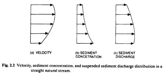
A typical relationship among velocity, sediment concentration and sediment discharge for different depths at the centre of a straight natural channel is shown in Fig. 2.2. The quantity of sediment discharge is a product of velocity and concentration (Fig. 2.2).
Although, velocity is minimum at the bottom of the channel, high concentration of sediment near the channel bed accounts for the maximum sediment discharge. At a point just above the bottom of the channel, the distribution of fine sediment is more nearly uniform with depth as compared to that of coarse material.
b. Saltation:
In the movement of sediment by saltation, particles skip or bounce along the stream bed. The height of the bounce is directly proportional to the ratio of particle’s density to fluid density. In comparison to the total sediment transport, the saltation is considered to be of relatively lesser importance.
c. Surface Creep or Bed Load:
It is the movement of particles in almost continuous contact with the stream bed. Particles move downhill by the rolling or dragging action of water along the stream bed. Bed load may contribute about 10-50% of the total sediments.
Bed load movement can be expressed as:
Vt = ½ d4/9 (G – 1)1/2 …(2.1)
Where,
Vt = threshold velocity (fps)
d = particle diameter (mm)
G = specific gravity of particles
Control:
Soil erosion by water occurs simultaneously in two steps: the detachment, which is principally caused by falling raindrops; and the transport of the detached particles, which is principally caused by flowing water. Therefore, soil erosion can be minimised by preventing the detachment and the transport of soil particles.
A cover of vegetation and soil granulation helps to prevent the detachment of soil particles. The transportation of soil particles can be effectively minimised by artificial mechanical structures to control the effects of runoff.
The details of various principles in erosion control caused by water are discussed below:
1. Maintenance of Soil Infiltration Capacity:
When the rate of rainfall exceeds the rate of infiltration of the water into the soil, hence every factor that reduces the infiltration of the soil increases the likelihood of water runoff.
Being a dynamic property the infiltration rate is most affected by soil surface condition which varies with crop, climate and tillage practices. The greater the vegetation, the higher will be the beneficial effects of plants in maintaining an open soil structure. In general, grasses encourage infiltration capacity.
Long dry spell increases infiltration capacity of soil because of the severe cracking of soil which permits rapid entry of rainfall into the soil. Tillage practices also affect infiltration capacity of soil. Tillage practices which compact the soil decrease the infiltration capacity and practices which loose the soil are likely to increase the infiltration capacity.
We know that when rain drop strikes the bare surface, the soil crumb or aggregates disintegrate and choke the pore space making the soil virtually impermeable to water. Hence, the most successful method to keep soil permeable would be to prevent the rain actually hitting the soil.
As it would be difficult to keep soil permeable under most circumstances, because the main cause of erosion is heavy rain storms, it is practicable to adapt a practice which would enhance stability of aggregates strong enough to withstand such impacts of raindrops.
2. Soil Protection from Rainfall:
Covering the soil is to protect it from the rainfall impact. The soil surface can be protected from the rain drops either by raising a close growing crop or by covering with straw, farm yard manure or leaf mulch. A soil devoid of vegetation is subjected to rainfall impact and begins to erode.
Vegetative cover on the soil may reduce erosion by:
(a) Interception of rainfall by vegetative cover;
(b) Decreasing the velocity of runoff and cutting action of water;
(c) Increasing granulation and porosity; and
(d) Reducing soil drying.
The effects of these are interdependent in erosion control.
The interception of raindrop by canopy reduces the erosion in two ways. First, vegetative crop absorbs the kinetic energy of falling rain drops and reduces the risk of soil being impermeable due to beating actions of falling rain drops. Second, a part of intercepted rainfall does not reach the ground but is evaporated from plant surfaces.
The amount and distribution of plant cover affects the impact of raindrops. Soil surface can be covered either by growing crops on it or by covering with straw or crop residues. Close growing crops provide better protection to soil against erosion than row-crops with clean cultivation. In fact, soils with enough plant cover have practically little problem of erosion.
The plant cover on soil surface shatters the kinetic energy of falling rain drops and thus little energy is available for breakdown of soil structure. A close growing crop not only slows down the velocity of water but also prevents concentration of water at a point. These two help in minimising the cutting power of the water.
3. Control of Surface Runoff:
The principal function of runoff in erosion is transportation of soil material before concentrating into gullies.
The runoff water has two consequences:
(a) The more runoff the greater is the ‘flash’ flood in the river draining after rain; and
(b) The greater is the amount of silt deposited by the river after the floods have receded.
Hence, runoff poses serious problem of flood control on one hand and silt control on the other. The damage caused by surface runoff can be reduced by controlling the concentration of runoff and regulating its velocity.
Hence the fundamental principle of combatting or reducing soil erosion by water is to reduce the amount of runoff as much as possible and ensuring that whatever runoff occurs takes place as thin sheet of slowly moving water.
The concentration and velocity of runoff water may be regulated by controlling the length of the slope. The velocity of runoff can be reduced and can be made to flow uniformly over the soil surface by mechanical barriers.
4. Safe Disposal of Surface Runoff:
Runoff water becomes available when rainfall intensity exceeds the infiltration rate of the soil. Therefore, from water erosion control point of view, the ideal soil would be the one in which infiltration rate equals the rainfall intensity, even for rainfall of highest intensity recorded in the region.
However, this situation practically does not exist under field conditions. To minimise the loss of erosion runoff can be diverted to a nearby well protected slope.
Hence, fundamental principles in reducing soil erosion by water are the maintenance of permeability of soil, to reduce the amount of runoff as much as possible, and reduce the velocity and concentration of runoff and make ways for safe disposal of runoff water.
Science Fair Project # 5. Soil Erosion Caused by Wind:
Erosion by wind, although most common in arid and semi-arid regions, occurs to some extent in humid regions as well.
It is essentially a dry weather phenomenon and is accelerated wherever:
(1) The soil is loose, dry and reasonably finely divided;
(2) The soil surface is relatively smooth and vegetative cover is either absent or sparse;
(3) The field is sufficiently large; and
(4) The wind is sufficiently strong to initiate soil movement.
Wind takes up soil from one place and deposits at another. If unprotected, the wind would slowly remove organic matter, fine silt and clay fractions leaving sand and gravel behind. This sorting action leads to more erodible and less productive soil.
Although wind has been active as an erosive agent throughout geologic times, it has become much more destructive because of defective methods of handling the land. As in water erosion, the soil material in order to be transported by wind must first be loosened from its position on the surface of the land. It may then be lifted, rolled or bounced along the surface of the ground.
These processes are largely the result of wind turbulence, mainly eddies and irregularities of wind movement. Turbulence adds a vertical component to the wind and makes it more erosive. The ability of wind to move and pick up soil particles varies square to cube of the velocity. A wind velocity scale is given in Table 4.1.
Statistics indicate that (NCA, 1976) about 32 m ha land in the country is affected by wind erosion. This includes 23.49 m ha of desert and about 6.5 m ha of coastal sandy lands. The desert area is spread over the States of Rajas- than (16.688 m ha), Gujarat (0.704 m ha) and Haryana (1.4 m ha).
Even within the desert areas, there are pockets of agricultural activity, and, therefore, only 80 per cent of the total area has been considered as subject to soil erosion by wind.
Soil erosion is one of the major problems in the Indian or the Thar desert. Measurements made over a 3 year period (1973-75) of dust blowing from the surface to a height of 3 m indicated an average soil loss of 50 to 420 kg/ha as a dust storm at Jodhpur, and 510 kg/ha in Jaisalmer, where wind speeds are relatively higher.
Coastal sandy lands fall mostly in the States of West Bengal, Orissa, Andhra Pradesh, Tamil Nadu, Karnataka, Maharashtra and Gujarat, where heavy gusts of wind before the monsoon raise the clouds of dust or sand.
Control:
The greatest damage by wind erosion occurs during the summer season in dry- regions where soil surface is bare and wind velocity is at its peak. Soil erosion by wind also involves detachment and transport of soil particles by wind forces. Wind erosion starts when forces of lift and drag exerted by wind against the surface of the ground overcome the forces of gravity of individual soil particles.
Large aggregates or clods can effectively resist the forces of wind. However, finer particles are easily lifted or rolled by the wind along the soil surface and thus initiate soil movement. Soil movement is, therefore, dependent on the size and weight of soil particles. The basic principle of wind erosion control lies, therefore, in preventing movement of the soil.
This can be achieved in either of the following ways:
(a) Reducing wind velocity at the ground surface sufficient to prevent it being able to pick-up soil particles.
(b) Increasing the size of soil aggregates or covering the soil with a non- erodible surface.
(c) Trapping the saltating soil particles.
(d) Keeping the soil moist so that soil particles moving by saltation lose their momentum at the surface.
a. Reducing Wind Velocity at the Ground Surface:
A velocity gradient exists whenever wind blows over a surface. The velocity is lowest near the ground surface and increases as logarithm of the height above the surface. The most important reason of erosion in arid and semi-arid regions is atmospheric turbulence which increases the velocity of wind near the ground surface and results wind erosion especially on bare lands.
Therefore, attempt should be made to reduce the velocity of the wind at the soil surface as much as possible. The secret of reducing wind velocity lies in growing plants or vegetative residues that will protect the land from wind erosion better than any other practice. Such covers act as a barrier between the soil and wind and effectively reduce the force of the wind on the soil surface.
The climate is often too dry for most vegetation and trees to establish quickly in wind prone areas. Therefore, destruction of vegetative cover is the most common cause of wind erosion. These areas should be established with permanent vegetation wherever possible.
Velocity of wind may be reduced by placing obstruction in the path of wind. Such obstructions absorb much of the force of the wind and reduce its velocity. Bunding and planting trees on the bunds forming barriers is an example of reducing wind velocity on agricultural lands.
b. Increasing the Size of Soil Aggregates:
Soil particles are moved by the direct pressure of the wind and impact of other particles moving along the surface of the ground. The threshold velocity is at a minimum for particles between 0.1 and 0.15 mm and, therefore, particles having diameter in this range are most erodible.
One of the principles, therefore, in wind erosion control is the creation of larger aggregates which are less susceptible to wind erosion. Course textured sandy loams, loamy sands and sands are most susceptible to erosion as they do not form stable clods because of low organic matter content.
Hence, organic matter plays important role in forming stable aggregates which are less likely to be eroded. High organic matter content in soil is often associated with high fertility and good tilt. Micro-organisms attack vegetative matter and bind the soil particles to form aggregates as a result of the production of a number of cementing materials.
The virgin soils brought under cultivation recently are seldom blown by wind. However, with repeated cultivation, the stability of aggregates is weakened making the soil liable to be eroded. Also, repeated tillage operations aimed at weed control increase chances of wind erosion because tillage operations reduce aggregate size.
c. Trapping Saltating Soil Particles:
The fine particles, which are not brought in motion by direct action of wind, are set in motion during saltation process which is due to direct pressure of wind on soil particles and their collision with other particles.
Thus trapping of eroding soil particles would be most effective in reducing further soil loss. Trapping may be accomplished by roughening the surface by placing barriers in the path of the wind, or by burrying the erodible particles by tillage. Trapping is also accomplished naturally by soil crusting.
Saltating particles can be trapped most effectively by a vegetative cover or thick stubble. Strips of tall growing crops or stubbles across the prevailing wind direction help in trapping the soil particles carried by saltation.
The minimum width of cultivated and uncultivated strips depends upon the movement of particles in a single leap. It has been observed that a 3 m strip apart would be effective in trapping 90 to 98% of the saltating particles.
Tillage is probably the most common and deliberate erosion control practice. It can be temporarily very effective if done properly. The basic element in erosion control by tillage is the creation of rough, cloudy surface which will resist the force of wind, decrease its velocity at the ground level and trap the moving soil.
The roughness of soil achieved by any of the tillage operations offers significant scope for wind erosion control. Soil clods prevent wind erosion because they are large enough to resist the forces of the wind and provide shelter to other erodible materials.
Various types of implements such as sub-soil plough, mould board plough, listers, etc. have been used to provide rough surface to the soil. A few clods will be formed with most tillage tools, but some tools are better than others. Ploughs are better than disc which inverts the soils.
d. Keeping the Soil Surface Moist:
Wind erosion is most prevalent only in arid and semi-arid regions because water, which effectively holds soil grains together by surface tension forces, is scarce or absent. Removal of wet soil particles is difficult by wind. Surface of the soil can be kept moist through irrigation or crop residue mulch.
Since it is not possible to keep soil moist in arid regions, attempts should be made to grow some economic crop which may keep soil covered and moist, thus, making it less vulnerable to wind erosion. Timely application of irrigation for wind erosion control makes possible the growth of vegetation and creates moist condition amenable to the development cloddy surface by tillage.
The cohesive force of water films enveloping the soil particles holds them in fragile larger units. A slight compaction by tillage at optimum moisture increases this cohesion further. Under certain conditions, it would require continuous irrigation to keep the soil surface wet enough to prevent erosion.
Keeping these principles in mind, various methods of wind erosion control are categorized below depending upon the nature of the problem in specific situations.
